


[:en]
The after-earthquake survey has to guarantee time-savings, high precision and security during the operational stages. The main goal is to optimize the application of methodologies based on acquisition and automatic elaborations of photogrammetric data even with the use of Unmanned Aerial Vehicle (UAV) systems in order to provide fast and low cost operations. The suggested methods integrate new technologies with commonly used technologies like TLS and topographic acquisition. The value of the photogrammetric application is demonstrated by a test case, based on the comparison of acquisition, calibration and 3D modeling results in case of use of a laser scanner, metric camera and amateur reflex camera.
The test would help us to demonstrate the efficiency of image based methods in the acquisition of complex architecture. The case study is Santa Barbara Bell tower in Mantua. The applied survey solution allows a complete 3D database of the complex architectural structure to be obtained for the extraction of all the information needed for significant intervention. This demonstrates the applicability of the photogrammetry using UAV for the survey of vertical structures, complex buildings and difficult accessible architectural parts, providing high precision results.
The church of Santa Barbara is located in the old town center of Mantua and is one of the most representative buildings in the city. On May 20th and 29th 2012 two big earthquake shocks were felt across a large part of the north of Italy. During that earthquake many buildings were damaged and afterward it was necessary to batten down the hatches by building temporary structures for safety of the buildings and people. In the Santa Barbara bell tower, the top was the most damaged part. The dome’s lantern collapsed and in its fall broke off a part of the summit balcony, in addition to some areas of surrounding buildings.
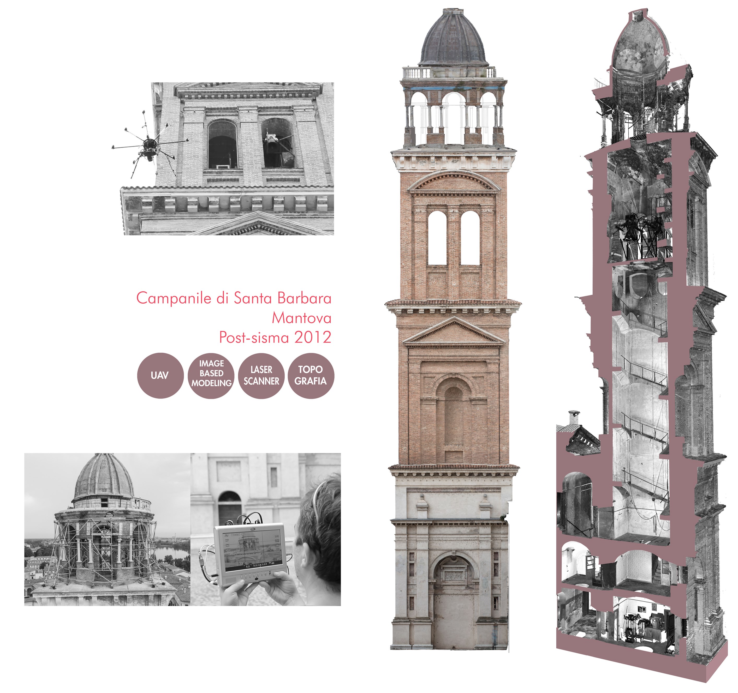
In geomatics, the use of UAVs is a low cost alternative to traditional airborne photogrammetry for large scale topographic mapping or recording detailed 3D information of terrestrial objects and integratation with the data collected by terrestrial acquisition (for example laser scanning). UAV aerial photogrammetry cannot replace traditional photogrammetry and satellite mapping application for large territories, but they give an efficient solution for little areas and large scale surveys. This is the case of Cultural Heritage applications. Moreover, these little flying vehicles give rapid solutions to some long-standing unsolved problems, such as for example the high resolution survey of pavements and vertical surfaces such as, for example, tall towers.

cfr. Achille C., Adami A., Chiarini S., Cremonesi S., Fassi F., Fregonese L., Taffurelli L. (2015). UAV-Based Photogrammetry and Integrated Technologies for Architectural Applications—Methodological Strategies for the After-Quake Survey of Vertical Structures in Mantua (Italy). Sensors, 15(7), 15520–15539. http://doi.org/10.3390/s150715520
[:]